Transjordan
By Ferrell Jenkins
Published in Biblical Insights
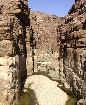
September, 2003The Arnon. The water from the Transjordan tableland flows east from an elevation of more than 5000 feet to the Dead Sea (nearly 1300 feet below sea level). This picture shows the Arnon a few yards before it reaches the Dead Sea. During the rainy season there is much more water. Photo © Ferrell Jenkins 2003.
The territory east of the Jordan River is commonly referred to as Transjordan. In Roman times the area was called Perea. The Greek phrase peran tou Iordanou is translated "beyond the Jordan" in English (Matt 4:15, 25; 19:1; Mark 3:8; 10:1; John 1:28; 3:36; 10:40).
Josephus described the North-South boundary of Perea as extending from Macherus (south of Mount Nebo) to Pella (south of the Sea of Galilee). On the west it was bounded by the Jordan River. The eastern limit reaches to Arabia, and cities like Philadelphia (modern Amman) and Gerasa (Jerash) (Jewish Wars 3.3.3), and the famous King's Highway (Num 20:17; 21:22).
The term Transjordan describes a larger region, but one that is still small. The New Bible Atlas describes the region between the river and the desert as "a narrow fertile belt, perhaps 30 km (16 miles) wide, running parallel with, and sometimes hidden behind, the savage, bare cliffs that overlook the Jordan and the Dead Sea." This fertile belt includes the territories of Moab, Ammon, Gilead, and Bashan. Rainfall is usually sufficient for good crops.
We speak of the Transjordan plateau or tableland (Hebrew, mishor; Deut 3:10; 4:43), but we should not think of a flat terrain. Remember that the Sea of Galilee is nearly 700 feet below sea level, and the Dead Sea is about 1300 feet below sea level. The Jordan River flows in that great rift, connecting the two bodies of water.
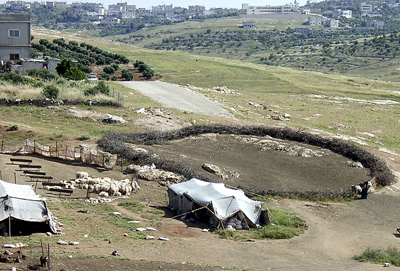
A sheep fold and olive groves in the hills of northern Gilead in Transjordan near modern Irbid. This terrain is typical of the plateau or tableland. The scene reminds one of the teaching of Jesus regarding the good shepherd and the sheep fold in John 10. The sheep are placed in the fold at night. Note the darkness of the soil within the fold. The Transjordan plateau is often 3000 feet above sea level. South of the Dead Sea, east of the Arabah, the elevation is nearly 5700 feet. What might be described as a tableland is intersected from east to west by some deep valleys, even gorges, in which rivers such as the Yarmuk, the Jabbok, the Arnon, and the Zered, flow. Much of the plateau consists of hills and valleys where cereal crops and olive groves flourish.
The tribes of Reuben, Gad, and half of Manasseh recognized that much of Transjordan was suitable for cattle (Num 32; Josh 1). Mesha of Moab was known as a sheep-breeder (2 Kings 3:4). Other portions were favorable for agriculture (Ruth 1:1, 6). The eastern side of the Jordan valley, with its lower elevation, is noted today for its fruits and vegetables, and several crops a year can be grown.Photos © Ferrell Jenkins 2003.
The photos may be used by others in teaching, but may not be used commercially or on web sites without permission.